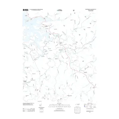
2013 Map of Robbinsville
USGS Topo · Published 2013About this map
Robbinsville sits at the heart of this North Carolina mountain landscape, where the town and its outlying settlements like Milltown and Sweetgum occupy the valleys between high knobs and ridges. The map records a complex land ownership pattern, specifically identifying numerous numbered and named land tracts such as the 93 Land Tract and the John Teeseteska Land Tract. To the northwest, the irregular shoreline of Lake Santeetlah creates a distinct recreational and residential zone, featuring Pine Ridge Camp and the Ceoah Paint Campground.
Find a feature on this map
145 named features on this map. Tap any name to fly to it.
Don’t see what you’re looking for? This feature index may not catch every label — zoom into the map to look around manually.
Map Details
Editions of this 2013 Robbinsville Map
This is the sole edition of this map. No revisions or reprints were ever made.
Other maps of this area

1933 · Bushnell
USGS Topo · 1:62,500

1935 · Robbinsville
USGS Topo · 1:24,000

1935 · Fontana
USGS Topo · 1:24,000

1935 · Topton
USGS Topo · 1:24,000

1935 · Marble
USGS Topo · 1:24,000

1935 · Wayah Bald
USGS Topo · 1:48,000

1935 · Santeetlah Creek
USGS Topo · 1:24,000

1935 · Andrews
USGS Topo · 1:24,000
1935 · Tapoco
USGS Topo · 1:24,000

1936 · Proctor
USGS Topo · 1:24,000