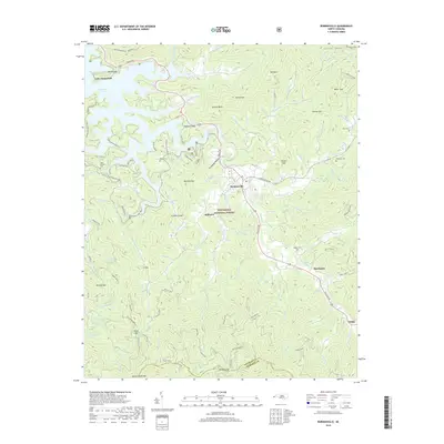
2019 Map of Robbinsville
USGS Topo · Published 2019About this map
Robbinsville serves as the central hub of this mountain landscape, positioned where the valley floors of Sweetwater Creek and Tulula Creek converge. The town is surrounded by the dense reaches of the Nantahala National Forest, with the expansive waters of Lake Santeetlah and its various coves, such as Shope Cove, dominating the northwestern quadrant. This 2019 survey documents a landscape defined by its high-elevation gaps and basins, including Snowbird Gap and Highland Gap, which have historically dictated the paths of travel through the Unicoi Mountains.
Find a feature on this map
101 named features on this map. Tap any name to fly to it.
Don’t see what you’re looking for? This feature index may not catch every label — zoom into the map to look around manually.
Map Details
Editions of this 2019 Robbinsville Map
This is the sole edition of this map. No revisions or reprints were ever made.
Other maps of this area

1933 · Bushnell
USGS Topo · 1:62,500

1935 · Robbinsville
USGS Topo · 1:24,000

1935 · Fontana
USGS Topo · 1:24,000

1935 · Topton
USGS Topo · 1:24,000

1935 · Marble
USGS Topo · 1:24,000

1935 · Wayah Bald
USGS Topo · 1:48,000

1935 · Santeetlah Creek
USGS Topo · 1:24,000

1935 · Andrews
USGS Topo · 1:24,000
1935 · Tapoco
USGS Topo · 1:24,000

1936 · Proctor
USGS Topo · 1:24,000