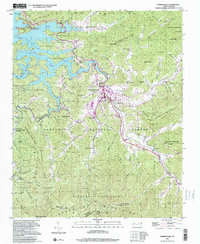
2000 Map of Robbinsville
USGS Topo · Published 2001About this map
Robbinsville serves as the focal point of this Graham County landscape, situated at the junction of Tulula Creek and Sweetwater Creek. The settlement pattern follows the valley floor, with Milltown and several small community centers established along the watercourses and roads leading into the Cheoah Mountains. A significant cultural landmark is the Zion Hill Ch Snowbird Cherokee Indian Sch, which points to the area's heritage as part of the land tracts belonging to the Eastern Band of Cherokee Indians. The western portion of the map is dominated by the intricate shoreline of Santeetlah Lake, where fingers of water extend into the Nantahala National Forest. Higher elevations like Teyahalee Bald overlook a terrain defined by named gaps and ridges, including Snowbird Gap and Atoah Gap, which historically dictated the movement of people and goods through this section of the Snowbird Mountains.
Find a feature on this map
87 named features on this map. Tap any name to fly to it.
Don’t see what you’re looking for? This feature index may not catch every label — zoom into the map to look around manually.
Map Details
Editions of this 2000 Robbinsville Map
This is the sole edition of this map. No revisions or reprints were ever made.
Other maps of this area

1933 · Bushnell
USGS Topo · 1:62,500

1935 · Robbinsville
USGS Topo · 1:24,000

1935 · Fontana
USGS Topo · 1:24,000

1935 · Topton
USGS Topo · 1:24,000

1935 · Marble
USGS Topo · 1:24,000

1935 · Wayah Bald
USGS Topo · 1:48,000

1935 · Santeetlah Creek
USGS Topo · 1:24,000

1935 · Andrews
USGS Topo · 1:24,000
1935 · Tapoco
USGS Topo · 1:24,000

1936 · Proctor
USGS Topo · 1:24,000