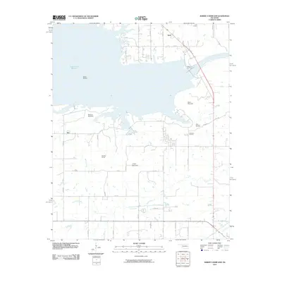
2010 Map of Robert S Kerr Dam
USGS Topo · Published 2010About this map
The Robert S Kerr Dam anchors this section of LeFlore County, where the Arkansas River is transformed into the expansive Robert S Kerr Reservoir. The landscape is a study in topographic contrast, defined by the lowlands of Blaine Bottom and the abrupt rises of Short Mountain, McCann Mountain, and Gingle Mountain. These heights overlook a grid of rural roads that connect small settlements like Brent and Star. For those researching local family history, several burial grounds are documented, including Brent Cemetery, Short Mountain Cemetery, and Cowlington Cemetery. The drainage patterns are well-defined by McCann Creek and Cache Creek, which thread through the valley floor beneath Brushy Knob. This 2010 survey illustrates the modern infrastructure of the dam alongside long-established rural community landmarks.
Find a feature on this map
48 named features on this map. Tap any name to fly to it.
Don’t see what you’re looking for? This feature index may not catch every label — zoom into the map to look around manually.
Map Details
Editions of this 2010 Robert S Kerr Dam Map
This is the sole edition of this map. No revisions or reprints were ever made.
Other maps of this area

1900 · Sallisaw
USGS Topo · 1:125,000

1911 · Sallisaw
USGS Topo · 1:125,000

1946 · Fort Smith
USGS Topo · 1:250,000

1965 · Fort Smith
USGS Topo · 1:250,000

1966 · Gans
USGS Topo · 1:24,000

1966 · Muldrow SW
USGS Topo · 1:24,000

1967 · Fort Smith
USGS Topo · 1:250,000
1967 · Keota
USGS Topo · 1:24,000
1967 · Sallisaw
USGS Topo · 1:24,000

1967 · Robert S Kerr Dam
USGS Topo · 1:24,000