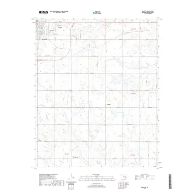
2018 Map of Roberta
USGS Topo · Published 2018About this map
The eastern edges of Durant and the surrounding rural landscape of Bryan County are meticulously documented in this detailed 2018 overview. The map captures a high degree of hydrological complexity, highlighting many family-named and numbered water bodies such as Anderson Lake, Conditt Lake, and Roberts Lake Number 1. Small settlements and historic crossroads like Roberta, Pirtle, and Allison anchor the township grid, while Old Allison provides a point of comparison for shifting local centers. Local history is further preserved through the marking of Pioneer Cem near the city's residential streets. The terrain is defined by the winding paths of Sassafras Cr and Long Cr, showing how the natural drainage patterns of the Red River valley shaped the placement of county roads like Old Hwy 70 and the various rural routes that crisscross the agricultural plots.
Find a feature on this map
66 named features on this map. Tap any name to fly to it.
Don’t see what you’re looking for? This feature index may not catch every label — zoom into the map to look around manually.
Map Details
Editions of this 2018 Roberta Map
This is the sole edition of this map. No revisions or reprints were ever made.
Other maps of this area

1899 · Atoka
USGS Topo · 1:125,000

1900 · Atoka
USGS Topo · 1:125,000

1954 · Sherman
USGS Topo · 1:250,000

1957 · Wade
USGS Topo · 1:62,500

1957 · Ardmore
USGS Topo · 1:250,000

1958 · Durant
USGS Topo · 1:62,500

1958 · Sherman
USGS Topo · 1:250,000

1963 · Ardmore
USGS Topo · 1:250,000
1968 · Durant North
USGS Topo · 1:24,000

1969 · Bokchito
USGS Topo · 1:24,000