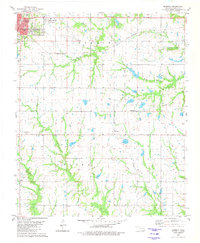
1980 Map of Roberta
USGS Topo · Published 1981About this map
Durant anchors the northwestern corner of this Bryan County landscape, where the town's grid meets an active Oil Field and the tracks of the St Louis - San Francisco railroad. The map documents a transition from the urban fringes of Lee Heights and the local George Washington Sch to a rural network of small communities and family-named landmarks. The topography is defined by the drainage systems of Sassafras Creek, Caney Creek, and Long Creek, which wind through the agricultural sections of Calera and Speirs. Genealogy researchers will find significant value in the location of the Pioneer Cem and the rural spiritual centers of Bushnell Ch and Pirtle Ch. The presence of both Allison and Old Allison provides a specific look at the shifting settlement patterns in southern Oklahoma during the mid-to-late 20th century.
Find a feature on this map
25 named features on this map. Tap any name to fly to it.
Don’t see what you’re looking for? This feature index may not catch every label — zoom into the map to look around manually.
Map Details
Editions of this 1980 Roberta Map
This is the sole edition of this map. No revisions or reprints were ever made.
Other maps of this area

1899 · Atoka
USGS Topo · 1:125,000

1900 · Atoka
USGS Topo · 1:125,000

1954 · Sherman
USGS Topo · 1:250,000

1957 · Wade
USGS Topo · 1:62,500

1957 · Ardmore
USGS Topo · 1:250,000

1958 · Durant
USGS Topo · 1:62,500

1958 · Sherman
USGS Topo · 1:250,000

1963 · Ardmore
USGS Topo · 1:250,000
1968 · Durant North
USGS Topo · 1:24,000

1969 · Bokchito
USGS Topo · 1:24,000