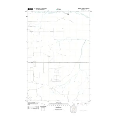
2011 Map of Roberts Corner
USGS Topo · Published 2011About this map
The Tahquamenon River snakes across the northern edge of this Luce County landscape, where the small settlement of McPhees Landing serves as a point of access to the water. The region is defined by a complex drainage network that includes the Sage River, the West Branch Sage River, and smaller tributaries like Thirtymile Creek and First Creek. The human footprint here is concentrated around Roberts Corner and Lencel, with the Luce County Hale Airport providing a vital regional connection in an area dominated by woods and waterways.
Find a feature on this map
24 named features on this map. Tap any name to fly to it.
Don’t see what you’re looking for? This feature index may not catch every label — zoom into the map to look around manually.
Map Details
Editions of this 2011 Roberts Corner Map
This is the sole edition of this map. No revisions or reprints were ever made.
Other maps of this area

1931 · Gould City NE
USGS Topo · 1:31,680

1931 · Gilchrist NE
USGS Topo · 1:31,680

1931 · Gilchrist NW
USGS Topo · 1:31,680

1954 · Sault Sainte Marie
USGS Topo · 1:250,000

1956 · Sault Sainte Marie
USGS Topo · 1:250,000

1957 · Sault Sainte Marie
USGS Topo · 1:250,000

1958 · Sault Sainte Marie
USGS Topo · 1:250,000

1962 · Auger Lake
USGS Topo · 1:24,000
1973 · Newberry
USGS Topo · 1:24,000
1973 · Gilchrist
USGS Topo · 1:24,000