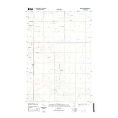
2014 Map of Roberts Corner
USGS Topo · Published 2014About this map
Tahquamenon River winds through the northern reaches of this Luce County landscape, where the riparian terrain gives way to the small settlements and transport hubs of the Michigan Upper Peninsula. The eastern edge of Newberry is documented alongside the rural communities of Roberts Corner and Lencel, illustrating the transition from town center to timber and wetland environments. The Luce County Airport serves as a modern anchor in a region defined by its hydrography, including the Sage River and the complex drainage of the West Br Sage River. Local infrastructure is mapped in detail, featuring named tracks such as the McLeod Truck Trl and Finn Aly, which reflect the area's logging and recreational utility. From the boat access at McPhees Landing to the straight-line corridors of Co Road 428, the map captures a network of forestry roads and remote homesteads.
Find a feature on this map
42 named features on this map. Tap any name to fly to it.
Don’t see what you’re looking for? This feature index may not catch every label — zoom into the map to look around manually.
Map Details
Editions of this 2014 Roberts Corner Map
This is the sole edition of this map. No revisions or reprints were ever made.
Other maps of this area

1931 · Gould City NE
USGS Topo · 1:31,680

1931 · Gilchrist NE
USGS Topo · 1:31,680

1931 · Gilchrist NW
USGS Topo · 1:31,680

1954 · Sault Sainte Marie
USGS Topo · 1:250,000

1956 · Sault Sainte Marie
USGS Topo · 1:250,000

1957 · Sault Sainte Marie
USGS Topo · 1:250,000

1958 · Sault Sainte Marie
USGS Topo · 1:250,000

1962 · Auger Lake
USGS Topo · 1:24,000
1973 · Newberry
USGS Topo · 1:24,000
1973 · Gilchrist
USGS Topo · 1:24,000