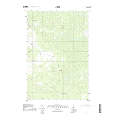
2019 Map of Roberts Corner
USGS Topo · Published 2019About this map
The Tahquamenon River winds along the northern reaches of this Luce County landscape, anchoring a region defined by extensive wetlands and a network of drainage systems. The eastern edge of Newberry appears in the northwest, while the small settlements of Roberts Corner and Lencel provide points of reference within the rural grid. The Big Ditch and several named creeks, such as Thirtynine Cr and the Sage River, indicate the significant water management required in this low-lying area. Transportation and recreation are centered around the Luce County Airport and the Canada Lakes Pathway, which cuts through the southern timberlands. A complex system of county roads and trails like the Mc Leod Truck Trl and Mcphee Landing Rd link these remote outposts, reflecting the area's continued reliance on forestry and regional transit.
Find a feature on this map
43 named features on this map. Tap any name to fly to it.
Don’t see what you’re looking for? This feature index may not catch every label — zoom into the map to look around manually.
Map Details
Editions of this 2019 Roberts Corner Map
This is the sole edition of this map. No revisions or reprints were ever made.
Other maps of this area

1931 · Gould City NE
USGS Topo · 1:31,680

1931 · Gilchrist NE
USGS Topo · 1:31,680

1931 · Gilchrist NW
USGS Topo · 1:31,680

1954 · Sault Sainte Marie
USGS Topo · 1:250,000

1956 · Sault Sainte Marie
USGS Topo · 1:250,000

1957 · Sault Sainte Marie
USGS Topo · 1:250,000

1958 · Sault Sainte Marie
USGS Topo · 1:250,000

1962 · Auger Lake
USGS Topo · 1:24,000
1973 · Newberry
USGS Topo · 1:24,000
1973 · Gilchrist
USGS Topo · 1:24,000