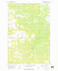
1973 Map of Roberts Corner
USGS Topo · Published 1977About this map
Newberry State Hospital and the outskirts of Newberry anchor the western edge of this Upper Peninsula landscape, where the cleared land of McMillan and Pentland townships gives way to the dense State Forest. The transport history of the region is deeply etched into the terrain, showing the active Soo Line rail corridor alongside vestiges of earlier industry like the Old RR Grade. To the north, the Tahquamenon River winds through the wetlands past McPhees Landing, while a network of drainage projects such as the Big Sage Ditch reveals the long-term efforts to manage the low-lying basin. From the aviation facilities at Luce County Airport to the small settlement at Roberts Corner, the map documents a mid-1970s transition point between established town centers and the wilder reaches of the Michigan backcountry.
Find a feature on this map
34 named features on this map. Tap any name to fly to it.
Don’t see what you’re looking for? This feature index may not catch every label — zoom into the map to look around manually.
Map Details
Editions of this 1973 Roberts Corner Map
This is the sole edition of this map. No revisions or reprints were ever made.
Other maps of this area

1931 · Gould City NE
USGS Topo · 1:31,680

1931 · Gilchrist NE
USGS Topo · 1:31,680

1931 · Gilchrist NW
USGS Topo · 1:31,680

1954 · Sault Sainte Marie
USGS Topo · 1:250,000

1956 · Sault Sainte Marie
USGS Topo · 1:250,000

1957 · Sault Sainte Marie
USGS Topo · 1:250,000

1958 · Sault Sainte Marie
USGS Topo · 1:250,000

1962 · Auger Lake
USGS Topo · 1:24,000
1973 · Newberry
USGS Topo · 1:24,000
1973 · Gilchrist
USGS Topo · 1:24,000