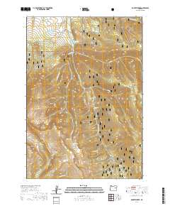
2020 Map of Roberts Creek
USGS Topo · Published 2020About this map
Malheur National Forest encompasses much of this high-elevation landscape in eastern Oregon, where the headwaters of the John Day River carve through the northern terrain. The presence of Blue Mountain Hot Springs near the river suggests the geothermal activity inherent to this portion of the Strawberry Range. The topographic patterns show a transition from the high ridges of Kimport Ridge to the high-mountain plateaus of Sunshine Flat and Little Meadows.
Find a feature on this map
29 named features on this map. Tap any name to fly to it.
Don’t see what you’re looking for? This feature index may not catch every label — zoom into the map to look around manually.
Map Details
Editions of this 2020 Roberts Creek Map
This is the sole edition of this map. No revisions or reprints were ever made.
Other maps of this area

1908 · Ironside Mountain
USGS Topo · 1:125,000

1955 · Canyon City
USGS Topo · 1:250,000

1959 · Canyon City
USGS Topo · 1:250,000

1959 · Prairie City
USGS Topo · 1:62,500

1961 · Logan Valley
USGS Topo · 1:62,500

1970 · Flag Prairie
USGS Topo · 1:62,500
1972 · Deardorff Mtn
USGS Topo · 1:24,000
1972 · Little Baldy Mnt.
USGS Topo · 1:24,000

1978 · John Day
USGS Topo · 1:100,000
1988 · Logan Valley East
USGS Topo · 1:24,000