
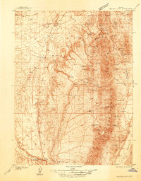
1926 Map of Roberts Mountains
USGS Topo · Published 1955About this map
Grass Valley and the Toiyabe Range anchor this mid-1920s survey of central Nevada, a landscape defined by isolated homesteads and high-desert springs. The settlement pattern is dominated by working ranches, including Hall Creek Ranch, Brackney Ranch, and Siri Ranch, reflecting the era's cattle and sheep economy. Educational infrastructure appears as small country schools like the Grass Valley Sch and Twin Springs Sch, which served the scattered families of the Great Basin. Mining activity is preserved in the location of the Keystone Mine and Birch Creek Mine. Notable hydrological features like Dianas Punch Bowl and Spencers Hot Springs stand out against the arid expanse of the Simpson Park Mountains and Kobeh Valley. The map also captures the path of Highway 50 as it crosses the Toiyabe National Forest, providing a detailed look at travel routes through the Great Basin before major modernization.
Find a feature on this map
131 named features on this map. Tap any name to fly to it.
Don’t see what you’re looking for? This feature index may not catch every label — zoom into the map to look around manually.
Map Details
Editions of this 1926 Roberts Mountains Map
This is the sole edition of this map. No revisions or reprints were ever made.
Other maps of this area

1907 · Tonopah
USGS Topo · 1:250,000

1908 · Tonopah
USGS Topo · 1:250,000

1929 · Roberts Mountains
USGS Topo · 1:250,000

1932 · Sonoma Range
USGS Topo · 1:250,000

1934 · Jiggs
USGS Topo · 1:125,000
1937 · Mineral Hill
USGS Topo · 1:48,000

1937 · Jiggs
USGS Topo · 1:125,000
1938 · Cortez
USGS Topo · 1:48,000

1939 · Sonoma Range
USGS Topo · 1:250,000

1943 · Mineral Hill
USGS Topo · 1:62,500