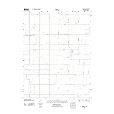
2012 Map of Robinson
USGS Topo · Published 2012About this map
Robinson serves as the primary settlement in this corner of Brown County, where the street grid includes local identifiers like Hack St and School St near the central Po. The surrounding agricultural landscape is defined by the complex drainage of the Wolf River system, including the N Fork Wolf River, Middle Fork Wolf River, and S Fork Wolf River. These waterways, along with Buttermilk Cr, carve through the prairie, creating a network of riparian corridors that contrast with the rigid section-line road system.
Find a feature on this map
47 named features on this map. Tap any name to fly to it.
Don’t see what you’re looking for? This feature index may not catch every label — zoom into the map to look around manually.
Map Details
Editions of this 2012 Robinson Map
This is the sole edition of this map. No revisions or reprints were ever made.
Other maps of this area

1885 · Atchison
USGS Topo · 1:125,000

1888 · Atchison
USGS Topo · 1:125,000

1888 · Hiawatha
USGS Topo · 1:125,000

1893 · Atchison
USGS Topo · 1:125,000

1894 · Hiawatha
USGS Topo · 1:125,000

1950 · Kansas City
USGS Topo · 1:250,000

1954 · Kansas City
USGS Topo · 1:250,000

1956 · Kansas City
USGS Topo · 1:250,000
1959 · White Cloud
USGS Topo · 1:24,000
1959 · Highland
USGS Topo · 1:24,000