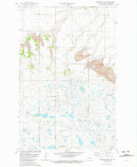
1981 Map of Robinson Coulee
USGS Topo · Published 1982About this map
Glacial prairie potholes and seasonal drainages define the landscape of Ward County in the early 1980s. The northern portion of the quadrangle is marked by deep erosional cuts including Bonnes Coulee, Robinson Coulee, and Newman Coulee, which contrast with the flatter terrain of Brillian and Greeley townships to the south. Land use in this era is a mix of conservation and extraction, evidenced by the expansive National Waterfowl Production Area pitted with small wetlands, and a significant Strip Mine operation near Bowers Coulee. Local history is anchored by the German Cem and Calvary Chapel, while infrastructure such as a rural Townhall, a Radio Tower, and a remote Landing Strip indicate the area's specialized transportation and communication needs during this period of North Dakota's development.
Find a feature on this map
18 named features on this map. Tap any name to fly to it.
Don’t see what you’re looking for? This feature index may not catch every label — zoom into the map to look around manually.
Map Details
Editions of this 1981 Robinson Coulee Map
This is the sole edition of this map. No revisions or reprints were ever made.
Other maps of this area

1929 · Sawyer
USGS Topo · 1:62,500

1929 · Benedict
USGS Topo · 1:62,500

1929 · Kongsberg
USGS Topo · 1:62,500

1948 · Velva
USGS Topo · 1:62,500

1948 · Sawyer
USGS Topo · 1:24,000

1949 · Sawyer
USGS Topo · 1:24,000

1949 · Velva
USGS Topo · 1:24,000

1949 · Sawyer
USGS Topo · 1:62,500
1950 · Sawyer SW
USGS Topo · 1:24,000

1951 · Velva
USGS Topo · 1:62,500