
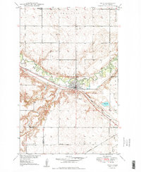
1949 Map of Velva
USGS Topo · Published 1949About this map
Velva sits at a strategic bend of the Souris River in the late 1940s, serving as a vital hub for the surrounding plains. The town is defined by the heavy presence of the Minneapolis St Paul and Sault Ste Marie railroad, which follows the river valley and supports the local economy. Beyond the town grid, the landscape transitions into the open terrain of North Prairie and Hendrickson, where the rural school system is visible through sites like School No 3 and Coulee Sch. The map reveals the intricate drainage patterns of the region, where Oak Creek and Bonnes Coulee feed into the main river valley. Small-scale industrial activity is evidenced by several Gravel Pits located near the rail line and riverbanks, highlighting the importance of local material extraction for maintaining the area's growing infrastructure.
Find a feature on this map
19 named features on this map. Tap any name to fly to it.
Don’t see what you’re looking for? This feature index may not catch every label — zoom into the map to look around manually.
Map Details
Editions of this 1949 Velva Map
2 editions found
Other maps of this area

1929 · Sawyer
USGS Topo · 1:62,500

1929 · Benedict
USGS Topo · 1:62,500

1929 · Kongsberg
USGS Topo · 1:62,500

1948 · Voltaire
USGS Topo · 1:24,000

1948 · Velva
USGS Topo · 1:62,500

1948 · Sawyer
USGS Topo · 1:24,000

1949 · Norwich
USGS Topo · 1:24,000

1949 · Sawyer
USGS Topo · 1:24,000

1949 · Simcoe
USGS Topo · 1:24,000

1949 · Sawyer NE
USGS Topo · 1:24,000