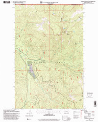
1997 Map of Robinson Mountain
USGS Topo · Published 2000About this map
Robinson Mountain dominates this remote stretch of the Kootenai National Forest along the international boundary between Montana and British Columbia. The high-elevation terrain is marked by essential forest service infrastructure, notably the Yaak Lookout, which overlooks a complex drainage system where the East Fork and West Fork converge into the main Yaak River channel. This 1997 revision of 1960s topography reveals a landscape defined by glacial lakes and steep timbered ridges, including Lake Geneva, Gold Lake, and Plumb Bob Lake. While largely wilderness, the presence of a Gravel Pit and established trails suggests the area's ongoing use for resource management and fire suppression. Notable watercourses like Caribou Creek, Young Creek, and Robinson Creek dissect the mountain slopes, while the 9th Standard Parallel North provides a formal surveying anchor across the forest floor.
Find a feature on this map
30 named features on this map. Tap any name to fly to it.
Don’t see what you’re looking for? This feature index may not catch every label — zoom into the map to look around manually.
Map Details
Editions of this 1997 Robinson Mountain Map
This is the sole edition of this map. No revisions or reprints were ever made.
Other maps of this area

1957 · Kalispell
USGS Topo · 1:250,000

1960 · Kalispell
USGS Topo · 1:250,000

1961 · Kalispell
USGS Topo · 1:250,000

1963 · Robinson Mountain
USGS Topo · 1:24,000

1963 · Red Mountain
USGS Topo · 1:24,000

1963 · Webb Mountain
USGS Topo · 1:24,000

1963 · Boulder Lakes
USGS Topo · 1:24,000

1963 · Mount Henry
USGS Topo · 1:24,000

1963 · Lost Horse Mountain
USGS Topo · 1:24,000

1979 · Yaak River
USGS Topo · 1:100,000