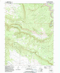
1994 Map of Roc Creek
USGS Topo · Published 1994About this map
The Dolores River winds through the eastern edge of this landscape, carving deep relief near Sewemup Mesa and the Manti La Sal National Forest. This 1994 edition reveals a rugged terrain defined by significant elevation changes, particularly between Sinbad Ridge and the Paradox Valley floor. The map provides a detailed look at the region's mining heritage, marking numerous operations including the Barium Cycle Mine, Redbird Mine, and the Sunrise Mine.
Find a feature on this map
40 named features on this map. Tap any name to fly to it.
Don’t see what you’re looking for? This feature index may not catch every label — zoom into the map to look around manually.
Map Details
Editions of this 1994 Roc Creek Map
This is the sole edition of this map. No revisions or reprints were ever made.
Other maps of this area

1885 · La Sal
USGS Topo · 1:250,000

1916 · Paradox Valley
USGS Topo · 1:125,000

1922 · Paradox Valley
USGS Topo · 1:125,000

1948 · Roc Creek
USGS Topo · 1:24,000

1948 · Paradox
USGS Topo · 1:24,000

1949 · Davis Mesa
USGS Topo · 1:24,000

1949 · Paradox
USGS Topo · 1:24,000

1949 · Roc Creek
USGS Topo · 1:24,000

1949 · Juanita Arch
USGS Topo · 1:24,000

1949 · Red Canyon
USGS Topo · 1:24,000