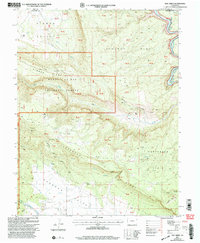
2001 Map of Roc Creek
USGS Topo · Published 2004About this map
Sinbad Valley and Paradox Valley converge in this western Colorado landscape, where early 21st-century mapping preserves a legacy of mineral exploration. The presence of the Radium Cycle Mine, Rajah Mine, and Sunrise Mine points to the region's history of uranium and vanadium mining. Between the high elevation of Sewemup Mesa and the deep cut of the Dolores River, the map reveals a rugged backcountry accessible largely by 4wd tracks and the Radium Trail. Human presence is sparse, marked by isolated points like Pace Ranch, a Corral, and a lone Grave near Roc Creek. Much of the territory falls within the Manti La Sal National Forest, where steep drainages like Garvey Gulch and Sunrise Canyon define the transition between the valley floors and the towering Carpenter Ridge.
Find a feature on this map
66 named features on this map. Tap any name to fly to it.
Don’t see what you’re looking for? This feature index may not catch every label — zoom into the map to look around manually.
Map Details
Editions of this 2001 Roc Creek Map
This is the sole edition of this map. No revisions or reprints were ever made.
Other maps of this area

1885 · La Sal
USGS Topo · 1:250,000

1916 · Paradox Valley
USGS Topo · 1:125,000

1922 · Paradox Valley
USGS Topo · 1:125,000

1948 · Roc Creek
USGS Topo · 1:24,000

1948 · Paradox
USGS Topo · 1:24,000

1949 · Davis Mesa
USGS Topo · 1:24,000

1949 · Paradox
USGS Topo · 1:24,000

1949 · Roc Creek
USGS Topo · 1:24,000

1949 · Juanita Arch
USGS Topo · 1:24,000

1949 · Red Canyon
USGS Topo · 1:24,000