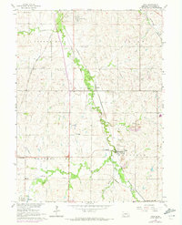
1964 Map of Roca
USGS Topo · Published 1973About this map
Salt Creek meanders northward through this rural Lancaster County landscape, acting as a geographic anchor for several small settlements and industrial operations. The map documents a dense network of rail lines including the Chicago and North Western, Union Pacific, and Burlington Northern, which served the region's agricultural and quarrying needs. At Roca, the landscape is defined by numerous quarries and a Gaging Sta, while Saltillo and Jamaica mark historic points along the river valley. Local life is recorded through foundational institutions like Trinity Chapel, Pioneer Sch, and the Saltillo-Simmons Cem.. The presence of smaller rail stops such as Hanlon and Rokeby illustrates the early 20th-century reliance on steam and diesel transport for moving local stone and produce to the state capital just to the north.
Find a feature on this map
37 named features on this map. Tap any name to fly to it.
Don’t see what you’re looking for? This feature index may not catch every label — zoom into the map to look around manually.
Map Details
Editions of this 1964 Roca Map
2 editions found
Other maps of this area

1897 · Lincoln
USGS Topo · 1:125,000

1955 · Lincoln
USGS Topo · 1:250,000

1957 · Lincoln
USGS Topo · 1:250,000

1958 · Lincoln
USGS Topo · 1:250,000

1964 · Cortland
USGS Topo · 1:24,000
1964 · Hallam
USGS Topo · 1:24,000

1964 · Denton
USGS Topo · 1:24,000

1964 · Roca
USGS Topo · 1:24,000

1964 · Walton
USGS Topo · 1:24,000
1964 · Emerald
USGS Topo · 1:24,000