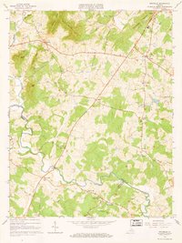
1964 Map of Rochelle
USGS Topo · Published 1966About this map
The Rapidan River and Conway River define the lower elevations of this mid-1960s landscape, where the borders of Madison, Greene, and Orange counties converge. The terrain is marked by prominent ridges like German Ridge and Carter Ridge, which separate the various runs and branches feeding the river systems. Settlement is concentrated in small, crossroads communities such as Shelby, Rochelle, and Wolftown, many of which grew around rural churches and local mills.
Find a feature on this map
54 named features on this map. Tap any name to fly to it.
Don’t see what you’re looking for? This feature index may not catch every label — zoom into the map to look around manually.
Map Details
Editions of this 1964 Rochelle Map
4 editions found
Other maps of this area

1892 · Gordonsville
USGS Topo · 1:125,000

1930 · Madison
USGS Topo · 1:48,000

1933 · Madison
USGS Topo · 1:62,500

1935 · Charlottesville
USGS Topo · 1:62,500

1939 · Charlottesville
USGS Topo · 1:62,500

1949 · Charlottesville
USGS Topo · 1:250,000

1949 · Charlottesville
USGS Topo · 1:62,500

1956 · Charlottesville
USGS Topo · 1:250,000

1961 · Gordonsville
USGS Topo · 1:62,500

1961 · Rapidan
USGS Topo · 1:62,500