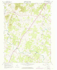
1964 Map of Rochelle
USGS Topo · Published 1973About this map
Madison serves as a primary northern anchor in this landscape, situated near the confluence of several watercourses including Courthouse Run and Little Dark Run. The terrain is defined by prominent elevations such as German Ridge and Tippets Mountain, which create a natural divide between the rolling lowlands and the more elevated ridges to the west. A network of small rural settlements like Wolftown, Shelby, and Pratts are connected by a system of roads that navigate the valleys of the Rapidan River and Conway River.
Find a feature on this map
52 named features on this map. Tap any name to fly to it.
Don’t see what you’re looking for? This feature index may not catch every label — zoom into the map to look around manually.
Map Details
Editions of this 1964 Rochelle Map
4 editions found
Other maps of this area

1892 · Gordonsville
USGS Topo · 1:125,000

1930 · Madison
USGS Topo · 1:48,000

1933 · Madison
USGS Topo · 1:62,500

1935 · Charlottesville
USGS Topo · 1:62,500

1939 · Charlottesville
USGS Topo · 1:62,500

1949 · Charlottesville
USGS Topo · 1:250,000

1949 · Charlottesville
USGS Topo · 1:62,500

1956 · Charlottesville
USGS Topo · 1:250,000

1961 · Gordonsville
USGS Topo · 1:62,500

1961 · Rapidan
USGS Topo · 1:62,500