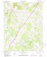
1964 Map of Rochelle
USGS Topo · Published 1987About this map
Wolftown and Shelby anchor this detailed study of the Virginia Piedmont, where the Rapidan River and its numerous tributaries like Beautiful Run and Elk Run carve through the landscape of Madison and Greene Counties. The map reflects a deeply rooted rural society defined by small hamlets and numerous country congregations, including Holy Trinity Ch, Elk Run Ch, and Pleasant Grove Ch.
Find a feature on this map
50 named features on this map. Tap any name to fly to it.
Don’t see what you’re looking for? This feature index may not catch every label — zoom into the map to look around manually.
Map Details
Editions of this 1964 Rochelle Map
4 editions found
Other maps of this area

1892 · Gordonsville
USGS Topo · 1:125,000

1930 · Madison
USGS Topo · 1:48,000

1933 · Madison
USGS Topo · 1:62,500

1935 · Charlottesville
USGS Topo · 1:62,500

1939 · Charlottesville
USGS Topo · 1:62,500

1949 · Charlottesville
USGS Topo · 1:250,000

1949 · Charlottesville
USGS Topo · 1:62,500

1956 · Charlottesville
USGS Topo · 1:250,000

1961 · Gordonsville
USGS Topo · 1:62,500

1961 · Rapidan
USGS Topo · 1:62,500