
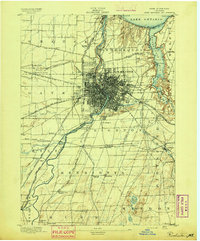
1965 Map of Rochester
USGS Topo · Published 1965About this map
The industrial and transport corridors of Upstate New York define this mid-century landscape, anchored by the metropolitan hubs of Rochester and Syracuse. Following the southern shore of Lake Ontario, the map illustrates a complex network of moving goods and people, from the historic Erie Canal and the massive rail lines of the New York Central and Lehigh Valley to the modern New York State Thruway. These arteries connect smaller manufacturing and canal towns like Newark, Lyons, and Oswego.
Find a feature on this map
116 named features on this map. Tap any name to fly to it.
Don’t see what you’re looking for? This feature index may not catch every label — zoom into the map to look around manually.
Map Details
Editions of this 1965 Rochester Map
This is the sole edition of this map. No revisions or reprints were ever made.
Other maps of this area

1893 · Sackets Harbor
USGS Topo · 1:62,500

1895 · Chittenango
USGS Topo · 1:62,500

1895 · Sacketts Harbor
USGS Topo · 1:62,500
1895 · Rochester
USGS Topo · 1:62,500
1895 · Stony Island
USGS Topo · 1:62,500

1895 · Ontario Beach
USGS Topo · 1:62,500

1895 · Pulaski
USGS Topo · 1:62,500

1895 · Watertown
USGS Topo · 1:62,500
1895 · Cape Vincent
USGS Topo · 1:62,500

1895 · Syracuse
USGS Topo · 1:62,500