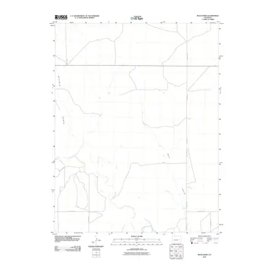
2010 Map of Rock Basin
USGS Topo · Published 2010About this map
Buffalo Basin and Rock Basin dominate this high plains landscape in Lincoln County, where the topography is defined by the ephemeral drainage of Rush Creek. This 2010 survey illustrates a sparsely populated ranching or agricultural region marked by a geometric grid of rural infrastructure. The map traces several arterial routes including County Road U and County Rd 38, which provide the primary connectivity across the basins. Unlike more developed areas, the focus here remains on the natural depressions and the seasonal watercourses that shape the eastern Colorado plains. The network of roads such as County Rd 43 and County Rd 63 follows the section lines, revealing the systematic land division that governs this quiet stretch of the frontier.
Find a feature on this map
10 named features on this map. Tap any name to fly to it.
Don’t see what you’re looking for? This feature index may not catch every label — zoom into the map to look around manually.
Map Details
Editions of this 2010 Rock Basin Map
This is the sole edition of this map. No revisions or reprints were ever made.
Other maps of this area

1891 · Arroyo
USGS Topo · 1:125,000

1893 · Arroyo
USGS Topo · 1:125,000

1954 · Lamar
USGS Topo · 1:250,000

1958 · Lamar
USGS Topo · 1:250,000
1978 · Kinney Lake
USGS Topo · 1:24,000

1978 · Aroya
USGS Topo · 1:24,000

1978 · Barrel Springs Draw
USGS Topo · 1:24,000

1978 · Rock Basin
USGS Topo · 1:24,000

1978 · Stacy Lakes Draw
USGS Topo · 1:24,000
1978 · Boyero
USGS Topo · 1:24,000