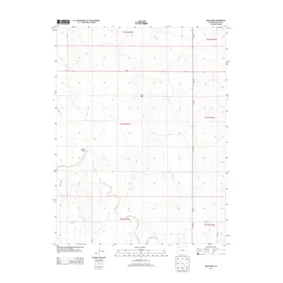
2013 Map of Rock Basin
USGS Topo · Published 2013About this map
Rock Basin and Buffalo Basin define the high plains landscape of Lincoln County in this 2013 survey. The terrain is characterized by these broad depressions and the meandering path of Rush Cr, which snakes through the southern sections of the township. This modern topographic study reveals a sparse, rural environment where movement is dictated by a rigid grid of local routes like Co-94 and CO Road 63. The mapping reflects a region dominated by large-scale ranching or agricultural divisions, with little in the way of concentrated settlement. Instead, the focus remains on the natural drainage patterns and the practical infrastructure of county roads, such as CO Road 38 and CO Road U, that provide access to this open Colorado country.
Find a feature on this map
18 named features on this map. Tap any name to fly to it.
Don’t see what you’re looking for? This feature index may not catch every label — zoom into the map to look around manually.
Map Details
Editions of this 2013 Rock Basin Map
This is the sole edition of this map. No revisions or reprints were ever made.
Other maps of this area

1891 · Arroyo
USGS Topo · 1:125,000

1893 · Arroyo
USGS Topo · 1:125,000

1954 · Lamar
USGS Topo · 1:250,000

1958 · Lamar
USGS Topo · 1:250,000
1978 · Kinney Lake
USGS Topo · 1:24,000

1978 · Aroya
USGS Topo · 1:24,000

1978 · Barrel Springs Draw
USGS Topo · 1:24,000

1978 · Rock Basin
USGS Topo · 1:24,000

1978 · Stacy Lakes Draw
USGS Topo · 1:24,000
1978 · Boyero
USGS Topo · 1:24,000