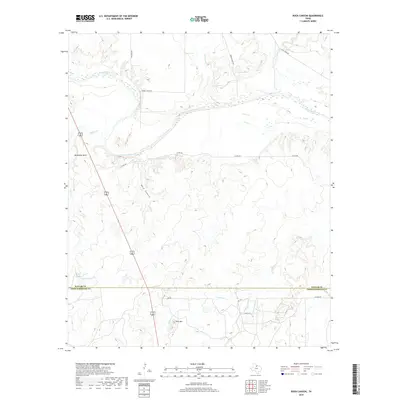
2019 Map of Rock Canyon
USGS Topo · Published 2019About this map
The Brazos River carves a winding path across this landscape, forming a dramatic loop at Horseshoe Bend in the northwest. This territory straddles the rural divide between Baylor Co and Throckmorton Co, where the elevation rises toward distinctive landforms like Twin Mtn and the namesake Rock Canyon. The drainage network is complex, with Millers Cr, Turkey Cr, and Deep Cr feeding into the main river channel from the north, while Wagon Cr and Dry Cr cross the southern plateaus.
Find a feature on this map
22 named features on this map. Tap any name to fly to it.
Don’t see what you’re looking for? This feature index may not catch every label — zoom into the map to look around manually.
Map Details
Editions of this 2019 Rock Canyon Map
This is the sole edition of this map. No revisions or reprints were ever made.
Other maps of this area

1954 · Wichita Falls
USGS Topo · 1:250,000

1958 · Wichita Falls
USGS Topo · 1:250,000

1962 · Antelope Creek SE
USGS Topo · 1:24,000

1962 · Antelope Creek NE
USGS Topo · 1:24,000

1966 · Seymour West
USGS Topo · 1:24,000

1966 · Westover SE
USGS Topo · 1:24,000

1966 · Rock Canyon
USGS Topo · 1:24,000

1966 · Westover SW
USGS Topo · 1:24,000

1966 · Seymour East
USGS Topo · 1:24,000
1966 · Cope Branch
USGS Topo · 1:24,000