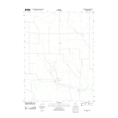
2011 Map of Rock Canyon
USGS Topo · Published 2011About this map
Highland Cemetery sits as a quiet landmark amidst the vast agricultural sections of Dundy County, illustrating the persistence of early prairie settlement patterns into the 21st century. The landscape is defined by the convergence of several waterways, including Muddy Creek, North Branch Indian Creek, and Indian Creek, which carve deep through the plains. The southern portion of the map is dominated by the Rock Canyon formation and the vital water management infrastructure at Anderson Reservoir and Anderson Dam. Tracing the road network reveals a mix of functional rural arteries such as Max-Wauneta Rd and more descriptively named paths like Oil Drilling Rd and Wash Board Rd, reflecting the region’s dual reliance on ranching and energy extraction. The transition from the flat uplands to the etched drainage of Kelly Gulch highlights the erosive nature of the high plains environment.
Find a feature on this map
16 named features on this map. Tap any name to fly to it.
Don’t see what you’re looking for? This feature index may not catch every label — zoom into the map to look around manually.
Map Details
Editions of this 2011 Rock Canyon Map
This is the sole edition of this map. No revisions or reprints were ever made.
Other maps of this area

1954 · McCook
USGS Topo · 1:250,000

1957 · McCook
USGS Topo · 1:250,000

1958 · McCook
USGS Topo · 1:250,000

1961 · Benkelman
USGS Topo · 1:24,000
1962 · Max SE
USGS Topo · 1:24,000

1962 · Max NE
USGS Topo · 1:24,000
1962 · Max
USGS Topo · 1:24,000

1973 · Ough
USGS Topo · 1:24,000

1973 · Wauneta SW
USGS Topo · 1:24,000
1973 · Rock Canyon
USGS Topo · 1:24,000