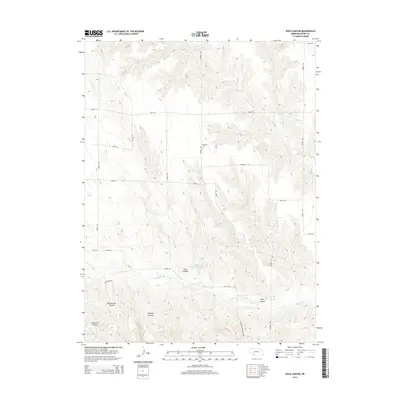
2014 Map of Rock Canyon
USGS Topo · Published 2014About this map
Highland Cem sits on a plateau overlooking a series of deeply carved drainages in this section of Dundy County. The landscape is defined by the sharp descent from the high plains into intricate canyon systems like Rock Canyon and Blackwater Canyon. Water management is evident in the presence of Anderson Reservoir, which captures runoff along the banks of Indian Cr. The map reveals a grid of rural roads and avenues that navigate the complex topography, providing access to remote areas such as Hickman Canyon and Kelly Gulch. A network of creeks, including Muddy Cr and the N Br Indian Cr, illustrates the drainage patterns that have sculpted this high prairie environment.
Find a feature on this map
27 named features on this map. Tap any name to fly to it.
Don’t see what you’re looking for? This feature index may not catch every label — zoom into the map to look around manually.
Map Details
Editions of this 2014 Rock Canyon Map
This is the sole edition of this map. No revisions or reprints were ever made.
Other maps of this area

1954 · McCook
USGS Topo · 1:250,000

1957 · McCook
USGS Topo · 1:250,000

1958 · McCook
USGS Topo · 1:250,000

1961 · Benkelman
USGS Topo · 1:24,000
1962 · Max SE
USGS Topo · 1:24,000

1962 · Max NE
USGS Topo · 1:24,000
1962 · Max
USGS Topo · 1:24,000

1973 · Ough
USGS Topo · 1:24,000

1973 · Wauneta SW
USGS Topo · 1:24,000
1973 · Rock Canyon
USGS Topo · 1:24,000