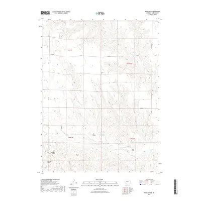
2017 Map of Rock Canyon
USGS Topo · Published 2017About this map
Highland Cem stands as a lonely landmark on the high ground of the Nebraska plains, surrounded by a complex system of drainage and canyonlands in Dundy County. This corner of the state is defined by its deep, eroded draws including Rock Canyon, Blackwater Canyon, and Hickman Canyon. The landscape is etched by the movements of Indian Cr and its tributaries, such as N Br Indian Cr, which flow toward the south and east. A sparsely populated grid of roads like Indian Creek Rd and Oil Drilling Rd reveals the region's agricultural and industrial utility. Water management in this semi-arid environment is represented by the Anderson Reservoir, while the named terrain features like Kelly Gulch and Cheyenne Canyon highlight the varied topography that breaks the level horizon of the high plains.
Find a feature on this map
29 named features on this map. Tap any name to fly to it.
Don’t see what you’re looking for? This feature index may not catch every label — zoom into the map to look around manually.
Map Details
Editions of this 2017 Rock Canyon Map
This is the sole edition of this map. No revisions or reprints were ever made.
Other maps of this area

1954 · McCook
USGS Topo · 1:250,000

1957 · McCook
USGS Topo · 1:250,000

1958 · McCook
USGS Topo · 1:250,000

1961 · Benkelman
USGS Topo · 1:24,000
1962 · Max SE
USGS Topo · 1:24,000

1962 · Max NE
USGS Topo · 1:24,000
1962 · Max
USGS Topo · 1:24,000

1973 · Ough
USGS Topo · 1:24,000

1973 · Wauneta SW
USGS Topo · 1:24,000
1973 · Rock Canyon
USGS Topo · 1:24,000