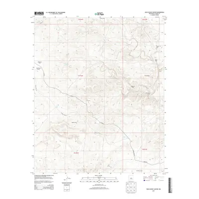
2013 Map of Rock House Canyon
USGS Topo · Published 2013About this map
Irwin Corn Ranch and Macho Ranch serve as the primary human markers in this ranching landscape of eastern New Mexico. The terrain is defined by a complex network of ephemeral drainages, most notably the winding Rock House Canyon and the wide Arroyo del Macho. These dry washes, including Eddleman Draw and China Draw, dictate the movement across the land, with Co Road 5 and Rocking Horse Rd following the natural contours of the high plains.
Find a feature on this map
26 named features on this map. Tap any name to fly to it.
Don’t see what you’re looking for? This feature index may not catch every label — zoom into the map to look around manually.
Map Details
Editions of this 2013 Rock House Canyon Map
This is the sole edition of this map. No revisions or reprints were ever made.
Other maps of this area

1955 · Roswell
USGS Topo · 1:250,000

1958 · Roswell
USGS Topo · 1:250,000

1962 · Roswell
USGS Topo · 1:250,000

1962 · Rock House Canyon
USGS Topo · 1:24,000

1962 · Panther Hill
USGS Topo · 1:24,000

1962 · Marley Draw
USGS Topo · 1:24,000
1963 · Barn Draw
USGS Topo · 1:24,000

1967 · Round Mountain SE
USGS Topo · 1:24,000
1967 · White Flat SE
USGS Topo · 1:24,000
1967 · Mesa SE
USGS Topo · 1:24,000