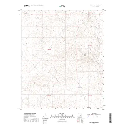
2023 Map of Rock House Canyon
USGS Topo · Published 2023About this map
Rock House Canyon and the winding Arroyo del Macho anchor this Chaves County landscape, where the drainage systems of the Pecos River basin define the local geography. The area's reliance on water management is evident through numerous collection points such as China Tank, Flores Tank, and Bajillo Tank, which are critical infrastructure in this arid environment. The transportation network is sparse, centered on the historic corridor of Rock House Rd and Co Rd 5, reflecting a traditional ranching economy. Deep topographic incisions like China Draw and Eddleman Draw cut through the terrain, illustrating the natural erosion patterns of the New Mexico high plains. These features together show a region meticulously organized by section lines and townships, where every draw and water tank serves as a primary landmark for navigation and land use.
Find a feature on this map
23 named features on this map. Tap any name to fly to it.
Don’t see what you’re looking for? This feature index may not catch every label — zoom into the map to look around manually.
Map Details
Editions of this 2023 Rock House Canyon Map
This is the sole edition of this map. No revisions or reprints were ever made.
Other maps of this area

1955 · Roswell
USGS Topo · 1:250,000

1958 · Roswell
USGS Topo · 1:250,000

1962 · Roswell
USGS Topo · 1:250,000

1962 · Rock House Canyon
USGS Topo · 1:24,000

1962 · Panther Hill
USGS Topo · 1:24,000

1962 · Marley Draw
USGS Topo · 1:24,000
1963 · Barn Draw
USGS Topo · 1:24,000

1967 · Round Mountain SE
USGS Topo · 1:24,000
1967 · White Flat SE
USGS Topo · 1:24,000
1967 · Mesa SE
USGS Topo · 1:24,000