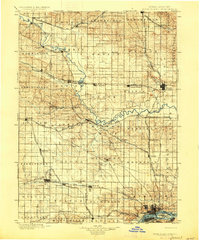
1901 Map of Rock Island
USGS Topo · Published 1927About this map
The Wapsipinicon River carves a winding path across this landscape at the turn of the century, serving as a natural boundary for several townships as it flows toward the Mississippi River. This era is defined by a dense web of competing rail lines, including the Chicago Milwaukee and St. Paul R.R. and the Chicago Rock Island and Pacific R.R., which fueled the growth of numerous small prairie settlements. Junctions like Oxford Junction and De Witt emerged as vital hubs for trade and transport. To the south, the industrial presence of the U.S. Arsenal on Rock Island stands in contrast to the rural character of the northern townships like Lost Nation and Brookfield. For the genealogist, the map preserves the exact locations of vanished river hamlets and milling sites like Oxford Mills and Rockingham, offering a detailed view of the settlement patterns before the dominance of modern highways transformed the eastern Iowa interior.
Find a feature on this map
94 named features on this map. Tap any name to fly to it.
Don’t see what you’re looking for? This feature index may not catch every label — zoom into the map to look around manually.
Map Details
Editions of this 1901 Rock Island Map
2 editions found

Other maps of this area

1889 · Tipton
USGS Topo · 1:62,500

1890 · Durant
USGS Topo · 1:62,500

1890 · Tipton
USGS Topo · 1:62,500

1891 · DeWitt
USGS Topo · 1:62,500

1891 · Davenport
USGS Topo · 1:62,500

1891 · Monticello
USGS Topo · 1:62,500

1891 · Maquoketa
USGS Topo · 1:62,500

1891 · Wilton Junction
USGS Topo · 1:62,500

1891 · Baldwin
USGS Topo · 1:62,500

1892 · Wheatland
USGS Topo · 1:62,500