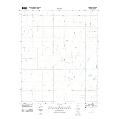
2012 Map of Rock Mary
USGS Topo · Published 2012About this map
Rock Mary stands as a prominent sandstone landmark in this section of Caddo County, a site with long-standing significance for western travelers. The landscape is defined by the drainage of Sugar Cr and its various tributaries, including the colorfully named Dead Woman Cr to the northwest. By the early 21st century, the hydrological profile of the area had been modified by several soil conservation and flood control projects, evidenced by the numbered reservoirs such as Sugar Cr Site 12 Reservoir and Sugar Cr Site 11 Reservoir, along with the Fast Runner Site 1 Reservoir. The grid of section line roads, including Bethel Rd, maintains the traditional agricultural rhythm of the Oklahoma plains, while the varied terrain around the creeks provides a break from the surrounding flatlands.
Find a feature on this map
27 named features on this map. Tap any name to fly to it.
Don’t see what you’re looking for? This feature index may not catch every label — zoom into the map to look around manually.
Map Details
Editions of this 2012 Rock Mary Map
This is the sole edition of this map. No revisions or reprints were ever made.
Other maps of this area

1942 · Geary
USGS Topo · 1:62,500

1951 · Binger
USGS Topo · 1:62,500

1955 · Clinton
USGS Topo · 1:250,000

1957 · Clinton
USGS Topo · 1:250,000

1961 · Eakly
USGS Topo · 1:62,500

1964 · Weatherford
USGS Topo · 1:62,500

1979 · Hinton
USGS Topo · 1:24,000

1979 · Sickles
USGS Topo · 1:24,000
1979 · Binger
USGS Topo · 1:24,000
1979 · Geary South
USGS Topo · 1:24,000