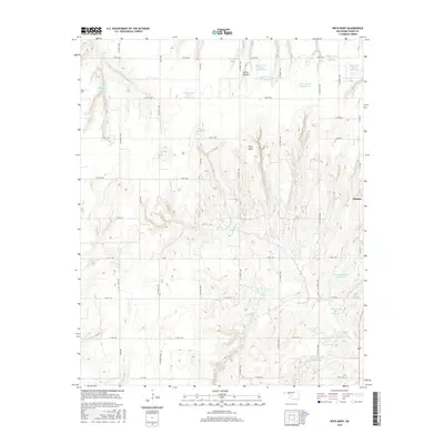
2016 Map of Rock Mary
USGS Topo · Published 2016About this map
Rock Mary, a notable sandstone landmark and historic trail marker, rises above the surrounding landscape in this 2016 survey of Caddo County. The terrain is defined by a dense network of water management features, including numerous named reservoirs such as Sugar Creek Site 15 Reservoir and Fast Runner Site 1 Reservoir. These impoundments are distributed along the drainage basins of Sugar Cr and Dead Woman Cr, reflecting a highly engineered hydrological environment designed for flood control and water storage. On the eastern edge of the map, the settlement of Hinton is visible, situated near the head of White Canyon. The land is divided by a regular grid of rural routes, including Co RD 1050 and Co RD 1100, which provide access to the dispersed agricultural properties and the various conservation sites that dominate the local geography.
Find a feature on this map
32 named features on this map. Tap any name to fly to it.
Don’t see what you’re looking for? This feature index may not catch every label — zoom into the map to look around manually.
Map Details
Editions of this 2016 Rock Mary Map
This is the sole edition of this map. No revisions or reprints were ever made.
Other maps of this area

1942 · Geary
USGS Topo · 1:62,500

1951 · Binger
USGS Topo · 1:62,500

1955 · Clinton
USGS Topo · 1:250,000

1957 · Clinton
USGS Topo · 1:250,000

1961 · Eakly
USGS Topo · 1:62,500

1964 · Weatherford
USGS Topo · 1:62,500

1979 · Hinton
USGS Topo · 1:24,000

1979 · Sickles
USGS Topo · 1:24,000
1979 · Binger
USGS Topo · 1:24,000
1979 · Geary South
USGS Topo · 1:24,000