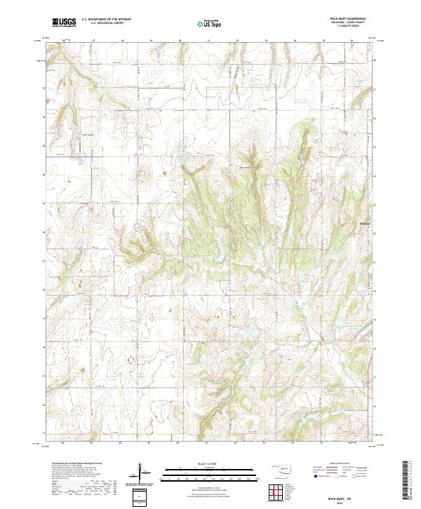
2022 Map of Rock Mary
USGS Topo · Published 2022About this map
Rock Mary stands as a prominent topographic landmark within this section of Caddo County, rising amidst a landscape defined by the intricate drainage of Sugar Creek. The western edge of the town of Hinton is visible on the eastern margin, showing its position relative to the surrounding agricultural grid and rugged canyon lands. The terrain is deeply incised by features such as White Canyon and the evocatively named Dead Woman Creek, illustrating the erosional patterns typical of the region. This 2022 survey details a complex system of water management, including the Sugar Creek Site 29 Reservoir, Sugar Creek Site 12 Reservoir, and the Fast Runner Site 1 Reservoir. Local aviation history is represented by Smith Airpark in the northwest, while a dense network of county roads like Bethel Road and County Road 1060 provides access to the scattered rural homesteads and section lines of the Public Land Survey System.
Find a feature on this map
43 named features on this map. Tap any name to fly to it.
Don’t see what you’re looking for? This feature index may not catch every label — zoom into the map to look around manually.
Map Details
Editions of this 2022 Rock Mary Map
This is the sole edition of this map. No revisions or reprints were ever made.
Other maps of this area

1942 · Geary
USGS Topo · 1:62,500

1951 · Binger
USGS Topo · 1:62,500

1955 · Clinton
USGS Topo · 1:250,000

1957 · Clinton
USGS Topo · 1:250,000

1961 · Eakly
USGS Topo · 1:62,500

1964 · Weatherford
USGS Topo · 1:62,500

1979 · Hinton
USGS Topo · 1:24,000

1979 · Sickles
USGS Topo · 1:24,000
1979 · Binger
USGS Topo · 1:24,000
1979 · Geary South
USGS Topo · 1:24,000