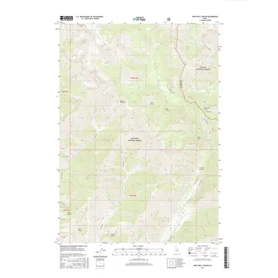
2017 Map of Rock Roll Canyon
USGS Topo · Published 2017About this map
The Boulder Mountains dominate the landscape of this high-elevation area on the boundary between Challis National Forest and Sawtooth National Forest. The map centers on the dramatic terrain where Trail Creek and its various tributaries carve through steep drainages like Cold Canyon and Rock Roll Canyon. The passage of Trail Creek Road over the Trail Creek Summit provides a vital corridor through the high peaks, connecting the different forest jurisdictions across the Blaine County and Custer County line.
Find a feature on this map
44 named features on this map. Tap any name to fly to it.
Don’t see what you’re looking for? This feature index may not catch every label — zoom into the map to look around manually.
Map Details
Editions of this 2017 Rock Roll Canyon Map
This is the sole edition of this map. No revisions or reprints were ever made.
Other maps of this area

1895 · Hailey
USGS Topo · 1:125,000

1897 · Hailey
USGS Topo · 1:125,000

1955 · Hailey
USGS Topo · 1:250,000

1959 · Hailey
USGS Topo · 1:250,000

1962 · Hailey
USGS Topo · 1:250,000
1967 · Meridian Peak
USGS Topo · 1:24,000

1967 · Rock Roll Canyon
USGS Topo · 1:24,000
1967 · Herd Peak
USGS Topo · 1:24,000

1967 · Sun Valley
USGS Topo · 1:24,000
1967 · Hyndman Peak
USGS Topo · 1:24,000