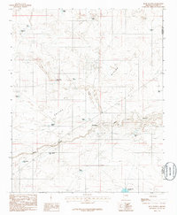
1986 Map of Rock Station
USGS Topo · Published 1986About this map
The Toltec Divide dominates this arid landscape in northern Arizona, marking a significant topographic ridge that separates seasonal water drainage systems. Rock Station serves as the primary named settlement, situated along a transportation corridor where the terrain begins to drop into the winding cuts of Jacks Canyon. This 1980s landscape is defined by its extensive water management infrastructure for ranching or local industry, evidenced by the numerous named stock tanks scattered across the quadrangle. The nomenclature of these water features, ranging from the Prairie Dog Tank and Horse Pasture Tank to the more uniquely named Model T Tank and Model A Tank, suggests a working landscape where every catchment point was identified for navigation and land use. In the southern reach, the Moonlight Bay Reservoir represents one of the larger impoundments in this otherwise high-desert environment.
Find a feature on this map
22 named features on this map. Tap any name to fly to it.
Don’t see what you’re looking for? This feature index may not catch every label — zoom into the map to look around manually.
Map Details
Editions of this 1986 Rock Station Map
This is the sole edition of this map. No revisions or reprints were ever made.
Other maps of this area

1883 · Tusayan
USGS Topo · 1:250,000

1886 · Tusayan
USGS Topo · 1:250,000

1886 · Holbrook
USGS Topo · 1:250,000

1893 · Holbrook
USGS Topo · 1:250,000

1947 · Flagstaff
USGS Topo · 1:250,000

1954 · Winslow
USGS Topo · 1:62,500

1954 · Winslow 4 SW
USGS Topo · 1:24,000

1954 · Flagstaff
USGS Topo · 1:250,000

1954 · Holbrook
USGS Topo · 1:250,000

1955 · Sunset Knoll 2 SW
USGS Topo · 1:24,000