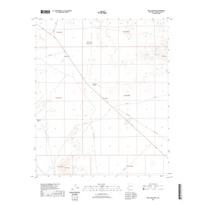
2020 Map of Rock Tank Draw
USGS Topo · Published 2020About this map
Rock Tank and its namesake Rock Tank Draw define this arid landscape in Hidalgo County, where water management is central to the terrain's history. The map illustrates a network of drainage features including Railroad Wash, Cottonwood Canyon, and Thompson Draw, which carve through the high desert between the Summit Hills to the south and the Black Hills in the northeast. This 2020 survey documents the modern ranching and energy infrastructure that underpins the region, from the Double M Ranch Rd to the prominent El Paso Gas Line crossing the southeastern corner. The arrangement of labeled features like Hughs Canyon and Dagger Draw reveals the complex topography of the Animas Valley area, where seasonal water flow and livestock requirements have historically dictated the location of vital points like the Rock Tank.
Find a feature on this map
23 named features on this map. Tap any name to fly to it.
Don’t see what you’re looking for? This feature index may not catch every label — zoom into the map to look around manually.
Map Details
Editions of this 2020 Rock Tank Draw Map
This is the sole edition of this map. No revisions or reprints were ever made.
Other maps of this area

1917 · San Simon
USGS Topo · 1:125,000

1926 · Orange Butte
USGS Topo · 1:62,500

1950 · San Simon
USGS Topo · 1:62,500

1951 · San Simon
USGS Topo · 1:62,500

1954 · Silver City
USGS Topo · 1:250,000

1958 · Silver City
USGS Topo · 1:250,000

1959 · Canador Peak
USGS Topo · 1:62,500

1960 · Duncan
USGS Topo · 1:62,500

1962 · Silver City
USGS Topo · 1:250,000
1962 · San Simon
USGS Topo · 1:62,500