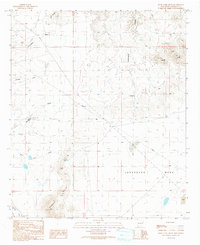
1990 Map of Rock Tank Draw
USGS Topo · Published 1991About this map
Lordsburg Mesa and the surrounding high desert of Hidalgo County are defined by a network of seasonal drainage channels in this 1986 field-checked survey. The landscape is marked by the rugged elevations of the Summit Hills and Black Hills, where the terrain drops into significant natural catchments and canyons. Essential water infrastructure for the arid region is documented through features like the Cottonwood Windmill and the namesake Rock Tank, which provided vital resources for local ranching and transit.
Find a feature on this map
19 named features on this map. Tap any name to fly to it.
Don’t see what you’re looking for? This feature index may not catch every label — zoom into the map to look around manually.
Map Details
Editions of this 1990 Rock Tank Draw Map
This is the sole edition of this map. No revisions or reprints were ever made.
Other maps of this area

1917 · San Simon
USGS Topo · 1:125,000

1926 · Orange Butte
USGS Topo · 1:62,500

1950 · San Simon
USGS Topo · 1:62,500

1951 · San Simon
USGS Topo · 1:62,500

1954 · Silver City
USGS Topo · 1:250,000

1958 · Silver City
USGS Topo · 1:250,000

1959 · Canador Peak
USGS Topo · 1:62,500

1960 · Duncan
USGS Topo · 1:62,500

1962 · Silver City
USGS Topo · 1:250,000
1962 · San Simon
USGS Topo · 1:62,500