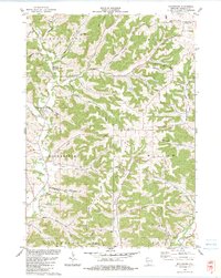
1983 Map of Rockbridge
USGS Topo · Published 1983About this map
Rockbridge and Hub City anchor this landscape where the Pine River and its numerous tributaries carve through the driftless terrain. The map documents a rural environment defined by narrow valleys and prominent ridges, including Pleasant Ridge and Richland Hill. Local spiritual and community centers are marked at Pleasant Ridge Ch and the Soules Creek Cem, providing vital reference points for genealogists. The topography is notably varied, featuring named hollows such as Happy Hollow and Steamboat Hollow, while recreational space is preserved at Pier Co Pk. Industrial activity is evident in several scattered quarries and a Sandpit, indicating the local reliance on geological resources. Transport is dictated by the land's contours, with routes like Scenic Drive and Happy Hollow Rd following the creek beds and ridge lines.
Find a feature on this map
46 named features on this map. Tap any name to fly to it.
Don’t see what you’re looking for? This feature index may not catch every label — zoom into the map to look around manually.
Map Details
Editions of this 1983 Rockbridge Map
This is the sole edition of this map. No revisions or reprints were ever made.
Other maps of this area

1905 · Richland Center
USGS Topo · 1:125,000

1927 · Hillsboro
USGS Topo · 1:62,500

1956 · Reedsburg
USGS Topo · 1:62,500

1958 · La Crosse
USGS Topo · 1:250,000

1960 · Richland Center
USGS Topo · 1:62,500

1960 · Plain
USGS Topo · 1:62,500

1961 · La Crosse
USGS Topo · 1:250,000

1965 · La Crosse
USGS Topo · 1:250,000

1966 · Hillsboro
USGS Topo · 1:62,500
1975 · La Valle
USGS Topo · 1:24,000