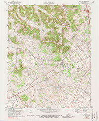
1979 Map of Rockfield
USGS Topo · Published 1988About this map
The Louisville and Nashville railroad corridor defines the settlement patterns of this central Kentucky landscape, connecting small communities like Rockfield and Petros as it cuts across the terrain. Numerous Oil Well sites are scattered throughout the region, particularly near Briggs Hill and the Whitestone Quarry, illustrating the area's local energy and industrial history during the mid-20th century. Local social centers are anchored by landmarks such as Rockfield Sch, Grace Ch, and Millikens Chapel, while the topography rises toward Providence Knob. This survey captures the rural character of Warren County before significant late-century development, where traditional agricultural life coexisted with active extractive industries. The map also delineates the boundaries where the county meets Logan and Simpson Counties to the southwest, providing a clear record of property and political lines in this part of the state.
Find a feature on this map
27 named features on this map. Tap any name to fly to it.
Don’t see what you’re looking for? This feature index may not catch every label — zoom into the map to look around manually.
Map Details
Editions of this 1979 Rockfield Map
This is the sole edition of this map. No revisions or reprints were ever made.
Other maps of this area

1914 · Little Muddy
USGS Topo · 1:62,500

1921 · Bowling Green
USGS Topo · 1:62,500

1922 · Brownsville
USGS Topo · 1:62,500

1923 · Bowling Green
USGS Topo · 1:62,500

1923 · Brownsville
USGS Topo · 1:62,500

1951 · Woodburn
USGS Topo · 1:24,000

1951 · Auburn
USGS Topo · 1:24,000

1951 · South Union
USGS Topo · 1:24,000

1952 · Rockfield
USGS Topo · 1:24,000

1954 · Evansville
USGS Topo · 1:250,000