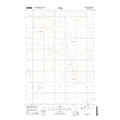
2015 Map of Rockham SW
USGS Topo · Published 2015About this map
Garfield Peak rises as a subtle topographic anchor in this Hand County landscape, where the prairie is defined by a grid of section-line roads and seasonal drainage systems. The survey reveals a region shaped by agricultural planning, with north-south routes like 361st Ave and 363rd Ave crossing east-west thoroughfares such as 174th St and 182nd St. Water is a defining seasonal presence here, with the meandering courses of Campbell Cr, N Wolf Cr, and Medicine Cr carving shallow paths through the sections. For those researching local history or genealogy, the Howell Cem near Pollock Rd represents a significant landmark of early settlement. The map provides a clear look at the township and range divisions, including t116n r68w and t115n r67w, illustrating the enduring structure of South Dakota's rural land management.
Find a feature on this map
24 named features on this map. Tap any name to fly to it.
Don’t see what you’re looking for? This feature index may not catch every label — zoom into the map to look around manually.
Map Details
Editions of this 2015 Rockham SW Map
This is the sole edition of this map. No revisions or reprints were ever made.
Other maps of this area

1899 · Redfield
USGS Topo · 1:125,000

1951 · Orient
USGS Topo · 1:24,000

1951 · Polo
USGS Topo · 1:24,000

1951 · Ree Heights NE
USGS Topo · 1:24,000

1953 · Huron
USGS Topo · 1:250,000

1954 · Huron
USGS Topo · 1:250,000

1966 · Burdette
USGS Topo · 1:24,000
1966 · Miranda
USGS Topo · 1:24,000
1966 · Rockham SW
USGS Topo · 1:24,000
1966 · Rockham
USGS Topo · 1:24,000