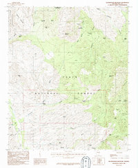
1986 Map of Rockinstraw Mountain
USGS Topo · Published 1986About this map
Rockinstraw Mountain and the surrounding high country of the Tonto National Forest dominate this mid-1980s topographical study. The landscape is defined by its water sources, with numerous labeled seeps and springs such as Cold Water Seep, Cherry Horizontal Spring, and Procopio Spring providing critical waypoints in the arid terrain. The Salt River Canyon Wilderness occupies the northern reaches, where the Salt River carves through the earth near Redmond Mountain.
Find a feature on this map
48 named features on this map. Tap any name to fly to it.
Don’t see what you’re looking for? This feature index may not catch every label — zoom into the map to look around manually.
Map Details
Editions of this 1986 Rockinstraw Mountain Map
This is the sole edition of this map. No revisions or reprints were ever made.
Other maps of this area

1901 · Globe
USGS Topo · 1:62,500

1902 · Globe
USGS Topo · 1:62,500

1922 · Chrysotile
USGS Topo · 1:125,000

1945 · Globe
USGS Topo · 1:24,000

1945 · Inspiration
USGS Topo · 1:24,000

1947 · Inspiration
USGS Topo · 1:24,000

1949 · Rockinstraw Mtn
USGS Topo · 1:62,500

1950 · Rockinstraw Mtn
USGS Topo · 1:62,500

1954 · Mesa
USGS Topo · 1:250,000

1957 · Mesa
USGS Topo · 1:250,000