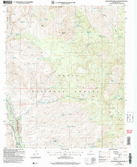
2004 Map of Rockinstraw Mountain
USGS Topo · Published 2007About this map
Salt River Canyon Wilderness and the high desert terrain of the Tonto National Forest dominate this Arizona landscape in Gila County. The topography is defined by prominent peaks like Rockinstraw Mountain and Granite Peak, where the drainage patterns of Negro Wash and Ash Wash carve into the Richmond Basin. The map captures a backcountry environment where water sources—essential for early ranching and mining operations—are meticulously labeled, from the Cherry Horizontal Well Spring to the Shute Road Well.
Find a feature on this map
54 named features on this map. Tap any name to fly to it.
Don’t see what you’re looking for? This feature index may not catch every label — zoom into the map to look around manually.
Map Details
Editions of this 2004 Rockinstraw Mountain Map
This is the sole edition of this map. No revisions or reprints were ever made.
Other maps of this area

1901 · Globe
USGS Topo · 1:62,500

1902 · Globe
USGS Topo · 1:62,500

1922 · Chrysotile
USGS Topo · 1:125,000

1945 · Globe
USGS Topo · 1:24,000

1945 · Inspiration
USGS Topo · 1:24,000

1947 · Inspiration
USGS Topo · 1:24,000

1949 · Rockinstraw Mtn
USGS Topo · 1:62,500

1950 · Rockinstraw Mtn
USGS Topo · 1:62,500

1954 · Mesa
USGS Topo · 1:250,000

1957 · Mesa
USGS Topo · 1:250,000