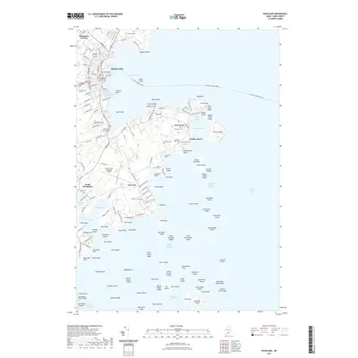
2021 Map of Rockland
USGS Topo · Published 2021About this map
Rockland serves as the central hub of this coastal survey, where the dense grid of streets including Park St and Main St meets the maritime activity of Rockland Harbor. The seat of local government is anchored by the Knox County Courthouse, while the surrounding neighborhoods of Blackinton Corners and Ingraham Hill spread inland. To the south, the landscape shifts toward the peninsula of Owls Head, home to the Evergreen Cem and the Knox County Regional Airport.
Find a feature on this map
167 named features on this map. Tap any name to fly to it.
Don’t see what you’re looking for? This feature index may not catch every label — zoom into the map to look around manually.
Map Details
Editions of this 2021 Rockland Map
This is the sole edition of this map. No revisions or reprints were ever made.
Other maps of this area

1904 · Vinalhaven
USGS Topo · 1:62,500

1904 · Tenants Harbor
USGS Topo · 1:62,500

1904 · Rockland
USGS Topo · 1:62,500

1905 · Penobscot Bay
USGS Topo · 1:125,000

1906 · Matinicus
USGS Topo · 1:62,500

1906 · Tennant Harbor
USGS Topo · 1:62,500

1906 · Rockland
USGS Topo · 1:62,500

1941 · Rockland
USGS Topo · 1:62,500

1941 · Vinalhaven
USGS Topo · 1:62,500

1944 · Vinalhaven
USGS Topo · 1:62,500