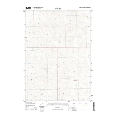
2015 Map of Rocky Butte Gulch
USGS Topo · Published 2015About this map
The Belle Fourche River crosses the northern edge of this high plains landscape, while the settlement of Wright anchors the southeastern corner. This area of Campbell County is defined by its complex drainage network and water management, visible through numerous catchments like the Rocky Gulch Reservoir, Marquiss Reservoir, and Rock Butte Number 2 Reservoir. These features, along with names like Dry Draw and Rocky Butte Gulch, reflect the arid nature of the terrain where seasonal water management is critical for ranching and industry. The map captures the land as it appeared in the mid-2010s, showing the intersection of natural drainage from Billie Cr and W Fork Hay Cr with the infrastructure of Wyoming Highway 387. Researchers can trace the section lines across townships T45N R73W and T44N R72W, which organize the expansive territory surrounding the community.
Find a feature on this map
15 named features on this map. Tap any name to fly to it.
Don’t see what you’re looking for? This feature index may not catch every label — zoom into the map to look around manually.
Map Details
Editions of this 2015 Rocky Butte Gulch Map
This is the sole edition of this map. No revisions or reprints were ever made.
Other maps of this area

1955 · Newcastle
USGS Topo · 1:250,000

1958 · Newcastle
USGS Topo · 1:250,000

1959 · North Star School
USGS Topo · 1:62,500

1960 · Turnercrest
USGS Topo · 1:62,500

1971 · Reno Junction
USGS Topo · 1:24,000

1971 · Little Thunder Reservoir
USGS Topo · 1:24,000
1971 · Eagle Rock
USGS Topo · 1:24,000

1974 · Reno Junction
USGS Topo · 1:100,000
1984 · Threemile Creek Reservoir
USGS Topo · 1:24,000
1984 · Persson Draw
USGS Topo · 1:24,000