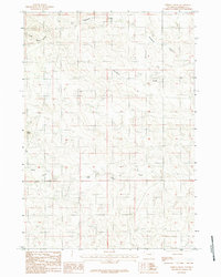
1984 Map of Persson Draw
USGS Topo · Published 1984About this map
Persson Draw and the surrounding drainage network of Campbell County define this 1984 provisional survey. The landscape is characterized by intermittent watercourses like Threemile Creek and Wild Horse Creek, which carve through the high plains. The topography is marked by significant elevations such as Black Butte, a prominent landmark in the western portion of the quadrangle. The map details the convergence of various waterways, including the North Prong and South Prong, illustrating the complex hydrological patterns of this rangeland region. As a provisional edition, it captures the rural character of the area following the mid-1970s aerial photography, showing a territory primarily shaped by natural terrain and local water features rather than dense settlement.
Find a feature on this map
7 named features on this map. Tap any name to fly to it.
Don’t see what you’re looking for? This feature index may not catch every label — zoom into the map to look around manually.
Map Details
Editions of this 1984 Persson Draw Map
This is the sole edition of this map. No revisions or reprints were ever made.
Other maps of this area

1953 · Savageton
USGS Topo · 1:24,000

1954 · Gillette
USGS Topo · 1:250,000

1955 · Newcastle
USGS Topo · 1:250,000

1955 · Gillette
USGS Topo · 1:250,000

1958 · Gillette
USGS Topo · 1:250,000

1958 · Newcastle
USGS Topo · 1:250,000

1959 · Savageton
USGS Topo · 1:62,500

1959 · North Star School
USGS Topo · 1:62,500

1962 · Gillette
USGS Topo · 1:250,000

1971 · Scaper Reservoir
USGS Topo · 1:24,000