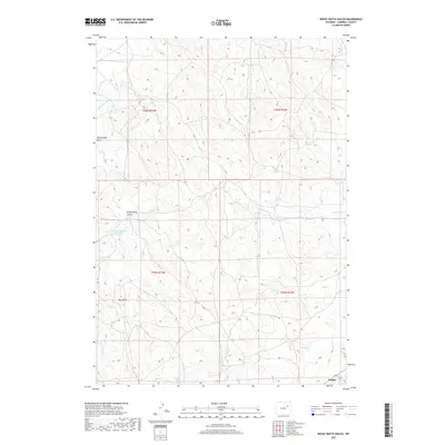
2017 Map of Rocky Butte Gulch
USGS Topo · Published 2017About this map
The town of Wright occupies the southeastern corner of this Campbell County survey, appearing just as modern energy development and ranching patterns shaped the local landscape. The terrain is defined by a series of intermittent drainage systems, most notably Rocky Butte Gulch and Dry Draw, which segment the rolling plains. Water management is a critical feature of this arid environment, evidenced by the Rock Butte Number 2 Reservoir and the headwaters of the Belle Fourche River in the northwest. To the east and south, the land is etched by the paths of W Fork Hay Cr, Hay Cr, and Billie Cr. This map provides a clear view of the rural road network and section boundaries that organize this part of the Powder River Basin.
Find a feature on this map
12 named features on this map. Tap any name to fly to it.
Don’t see what you’re looking for? This feature index may not catch every label — zoom into the map to look around manually.
Map Details
Editions of this 2017 Rocky Butte Gulch Map
This is the sole edition of this map. No revisions or reprints were ever made.
Other maps of this area

1955 · Newcastle
USGS Topo · 1:250,000

1958 · Newcastle
USGS Topo · 1:250,000

1959 · North Star School
USGS Topo · 1:62,500

1960 · Turnercrest
USGS Topo · 1:62,500

1971 · Reno Junction
USGS Topo · 1:24,000

1971 · Little Thunder Reservoir
USGS Topo · 1:24,000
1971 · Eagle Rock
USGS Topo · 1:24,000

1974 · Reno Junction
USGS Topo · 1:100,000
1984 · Threemile Creek Reservoir
USGS Topo · 1:24,000
1984 · Persson Draw
USGS Topo · 1:24,000