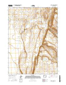
2017 Map of Rocky Canyon
USGS Topo · Published 2017About this map
Guano Rim dominates the central portion of this high desert landscape, creating a dramatic natural division between the eastern flats and the higher plateaus to the west. The 2017 terrain is characterized by seasonal water features and deep incisions like Rocky Canyon and Sage Hen Canyon, which funnel drainage toward Sage Hen Cr. Access through this remote corner of Lake County is primarily defined by the historic corridor of Beattys Butte Rd, which follows the north-south elevation contour. The presence of Shirk Lake and the descriptive Wagonslide landform suggest a history of early passage and livestock management in a region where water sources and navigable slopes dictated movement across the sagebrush steppe.
Find a feature on this map
13 named features on this map. Tap any name to fly to it.
Don’t see what you’re looking for? This feature index may not catch every label — zoom into the map to look around manually.
Map Details
Editions of this 2017 Rocky Canyon Map
This is the sole edition of this map. No revisions or reprints were ever made.
Other maps of this area

1955 · Adel
USGS Topo · 1:250,000

1957 · Adel
USGS Topo · 1:250,000

1958 · Adel
USGS Topo · 1:250,000

1962 · Adel
USGS Topo · 1:250,000

1967 · Alger Lake
USGS Topo · 1:24,000
1968 · Piute Reservoir
USGS Topo · 1:24,000

1968 · Guano Lake
USGS Topo · 1:24,000

1971 · Mahogany Butte
USGS Topo · 1:24,000
1971 · Rocky Canyon
USGS Topo · 1:24,000
1971 · Sage Hen Flats
USGS Topo · 1:24,000