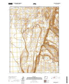
2020 Map of Rocky Canyon
USGS Topo · Published 2020About this map
Guano Rim defines the eastern escarpment of this high-desert landscape, where the dramatic elevation drop at Wagonslide reveals the steep transition from plateau to basin. The area is marked by seasonal water features like Shirk Lake and the drainage of Sage Hen Cr, which cuts through Sage Hen Canyon. While largely unsettled, the land is etched by Beattys Butte Rd, a primary access route through this corner of Lake County. This U.S. Geological Survey representation documents the complex topographic relief between Rocky Canyon and the surrounding desert, offering a detailed view of the natural hydrology and land management boundaries within the Oregon high desert. It is an essential document for understanding the physical geography and road networks in one of the state's most isolated regions during the early 21st century.
Find a feature on this map
13 named features on this map. Tap any name to fly to it.
Don’t see what you’re looking for? This feature index may not catch every label — zoom into the map to look around manually.
Map Details
Editions of this 2020 Rocky Canyon Map
This is the sole edition of this map. No revisions or reprints were ever made.
Other maps of this area

1955 · Adel
USGS Topo · 1:250,000

1957 · Adel
USGS Topo · 1:250,000

1958 · Adel
USGS Topo · 1:250,000

1962 · Adel
USGS Topo · 1:250,000

1967 · Alger Lake
USGS Topo · 1:24,000
1968 · Piute Reservoir
USGS Topo · 1:24,000

1968 · Guano Lake
USGS Topo · 1:24,000

1971 · Mahogany Butte
USGS Topo · 1:24,000
1971 · Rocky Canyon
USGS Topo · 1:24,000
1971 · Sage Hen Flats
USGS Topo · 1:24,000